Getting to the Lac Blanc Refuge

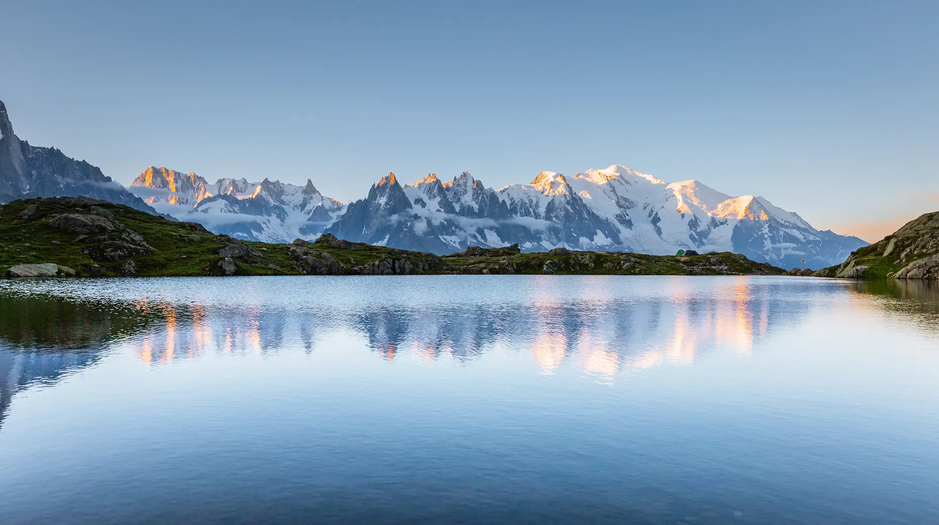
A jewel facing Mont Blanc

To reach the Lac Blanc Refuge, you have 3 options: 3 paths, 3 different starting points, for 3 different moods, desires, and levels…

Routes

Option 1 – Access from the Flégère cable car parking lot, in Les Praz de Chamonix.

3 routes available

Option 2 – Route via the Col des Montets Trail

Hiking time indicator icon 2h45
Height difference measurement icon 970 m
Trail difficulty rating icon 2 / 5

Option 3 – Route via the Tré-le-Champ Trail

Hiking time indicator icon 3h
Height difference measurement icon 990 m
Trail difficulty rating icon 3.5 / 5

1 – Route from the Flégère cable car parking lot, in Les Praz de Chamonix.

We recommend taking the Flégère cable car. It’s the most family-friendly option, avoiding a 2.5-hour ascent (a 1,560 m climb on a trail with little scenic interest) and bringing you directly to 1,850 m, at the foot of the ski area of the same name, facing Mont Blanc.

From there, you have several options:

When you get off the cable car, follow the sign for “Lac Blanc”. The path leads you straight into the heart of the Aiguilles Rouges massif, on a winding and rocky trail, but without any particular difficulty. 

Along the way, you can admire all the glaciers facing you: the Glacier du Tour, Glacier d’Argentière, Glacier des Grands Montets (famous for exceptional skiing), the Mer de Glace, as well as the Bossons and Taconnaz glaciers. You’ll also enjoy views of the iconic peaks of the Mont Blanc massif, including Mont Blanc itself, the Drus, the Grandes Jorasses, the Aiguille Verte, and many more — a panorama you won’t forget.

The trail is steep in some sections but never dangerous. Younger hikers may simply need to use their hands to get over the higher steps.

Once you reach the Lac Blanc Refuge, all that’s left to do is enjoy the incredible view.

Follow the sign for “Les Chéserys, Tête aux Vents”. Less steep than the previous trail but a bit more technical, this path — dotted with rocks, stones, and a few steps — first leads you to the small alpine hamlet of Les Chéserys, a reminder of the area’s pastoral past. At the foot of a waterfall and surrounded by greenery, you may spot marmots and ibex along the way. 

Then continue toward Tête aux Vents — a name that speaks for itself — and carry on toward Lac Blanc along a slightly steeper trail. It ends with a few short ladders (about 10 meters high) before revealing the turquoise waters of Lac Blanc and the refreshments offered by the refuge and its team.

From the Flégère cable car, take the Index chairlift, which will take you up to 2,595 meters. 

At the top, the trail descends to the right and runs alongside the small Lac du Fouet, often surrounded by snow patches that children love to play on. 

The balcony path offers an exceptional, uninterrupted panorama of the Mont Blanc range.

2 – Route via the Col des Montets Trail

Hiking time indicator icon 2h45
Height difference measurement icon 970 m
Trail difficulty rating icon 2 / 5

From Chamonix, follow the road toward Argentière and continue until you reach the Col des Montets parking area. From the Aiguilles Rouges Nature Reserve chalet, follow the signs for “Lac Blanc”.

This is the route for sporty hikers who prefer to avoid any fear-inducing sections, or for those sensitive to heights. It’s the final climb of the famous UTMB. The trail is winding, steep, and offers little shade, but has no technical difficulties apart from a few rocks to step over and some small steps.

Before reaching Lac Blanc, this balcony trail opens onto a plateau with an incredible view of Mont Blanc, its glaciers, its sharp peaks, and the crystal-clear waters of the Chéserys lakes, true gems facing Mont Blanc, where ibex and marmots often appear for your best photos!

The return is made via the same route as the ascent. Note that you can also descend using the alternative trail (Tré-le-Champ); the two parking areas are only 600 m apart.

3 – Route via the Tré-le-Champ Trail

Hiking time indicator icon 3h
Height difference measurement icon 990 m
Trail difficulty rating icon 3.5 / 5

From the parking area just above the hamlet of Tré-le-Champ, before the Col des Montets, follow the signs for “Lac Blanc”.

This trail, used by climbers to access the Chéserys slabs, should be avoided if you are afraid of heights. Toward the end, it includes around ten vertical ladders (10 to 15 meters high), a few sections with metal steps, and some handrails. Nothing difficult for those used to this type of terrain, but it can become challenging with a heavy backpack or at the end of the day when fatigue sets in. It should also be avoided in bad weather (rain, snow, thunderstorms…).

Note that during the peak summer season, when the trail is busy, crossing at the ladders (used for both ascending and descending) can be tricky and take some time. The trail remains very pleasant and is a must for adventurers, with more shade than the other routes and no difficulties until the ladder section.

After this technical section, which takes about 45 minutes to 1 hour in normal conditions, the trail leads you to Tête-aux-Vents, where it joins the other routes before reaching the famous Lac Blanc. Come prepared: be physically ready, well equipped, and carry enough water to fully enjoy the incredible panorama… Happy hiking!